Tour of the Western Pala Mountains
Colverde - Rifugio Velo - Pedemonte - Rifugio Pradidali - Passo di Ball - Col delle Féde - Val di Ròda
Canali Valley,Pala Group,San Martino di Castrozza
gian • 01/08/2019


Details
- Sport
- Hike
- Rating
- Difficulty
- Demanding
- Duration
- 10:00 hrs
- Length
- 22.5 km
- Vertigo
- No vertigo
- Min. elevation
- 1510 m
- Max. elevation
- 2443 m
- Elevation gain
- 2150 m
- Elevation loss
- 2150 m
- Car park
- View on Gmaps
Terrain
- 30%
- 5%
- 65%
- Forest
- Grass
- Rock
Seasons
- Jan
- Feb
- Mar
- Apr
- May
- Jun
- Jul
- Aug
- Sep
- Oct
- Nov
- Dec
Signposts
Description
Long and demanding loop starting and arriving in the village of San Martino di Castrozza. The hike touches the two main mountain huts of the southern part of the Pale di San Martino mountain range: Rifugio Velo della Madonna and Rifugio Pradidali. The itinerary takes well over eight hours and covers a significant shift in altitude, hence it is recommended only for expert hikers who want to have a long day immersed in the typical high altitude environment of the Dolomites.
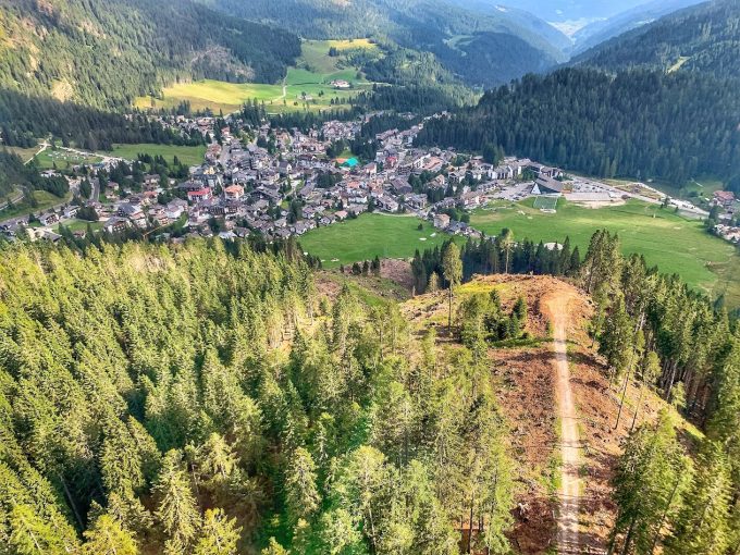
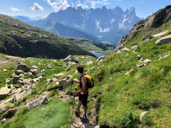
Starting from the start of the Colverde cable car, located on the edge of the village of San Martino di Castrozza, the track heads towards Sopra Col, following first the Signpost No. 702 “Val di Roda” and then the Signpost No. 721. The path climbs rapidly through the forest of pine trees and scree. While getting higher in altitude, the vegetation becomes less dense and beautiful views open over San Martino di Castrozza and the peak of Cima della Madonna (2,803 m asl).
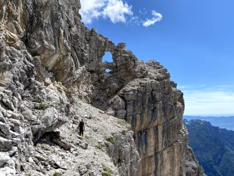
After a relatively easy stretch that runs along the eastern side of the peak of Cima Val di Roda (2,604 m asl), you arrive at the crossroads with the Signpost No. 713 “Lasta Moia”, main access to the hut of Rifugio Velo della Madonna (starting at Malga Civertaghe). The route becomes more demanding; the stretch on Signpost No. 713 that precedes the arrival at the hut has some exposed sections, where you can secure yourself on the provided fixed ropes.
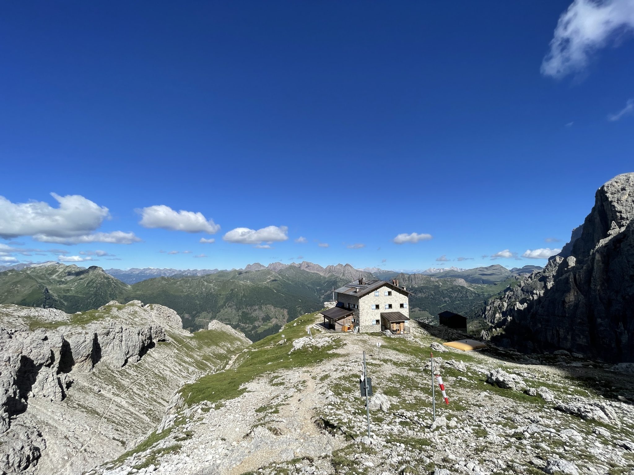
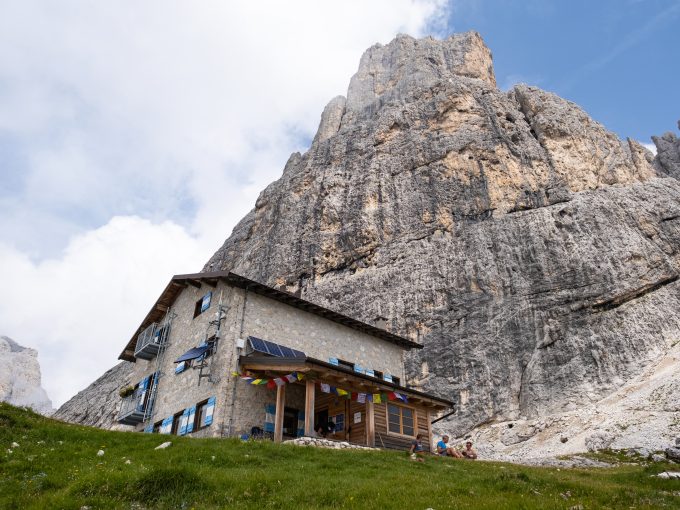
Once reached Rifugio Velo della Madonna (2,358 m asl) – the first of this long itinerary – the track continues along the Signpost No. 742 towards Sentiero del Cacciatore / Ferrata Dino Buzzati. In just under an hour, the ascent will take you to the mountain gap (2,420 m asl), located south of the peak of Stanga (2,547 m asl); once passed the gap, you will begin a long and technical descent along the Signpost No. 742, called “Sentiero Attrezzato del Cacciatore”. Although the most difficult and exposed parts do have support of fixed ropes, the descent, which has a vertical drop of about 1,000 m, must be carried out very carefully, especially if the ground is slippery. From the path, you can admire a sight to the wonderful Pradidali and Canali valleys, as well as on the peaks of Canali (2,859m asl), Madonna (2,803 m asl) and Sass Maór (2,551 m asl). Towards the end of the descent, in memory of the CAI Academician Giancarlo Biasin (who stumbled during the descent on the path of Cacciatore in 1964), you will find a plaque dedicated to him.
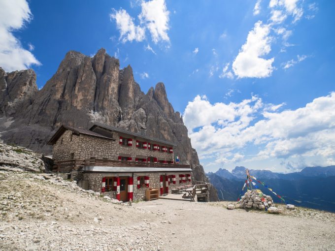
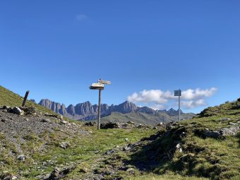
Arrived at the end of the long descent, the itinerary begins to become challenging again, with a significant positive shift in altitude that from the location of Portèla / Pedemonte (1,627 m asl) goes up the Val Pradidali along the Signspot No. 709, leading directly to the hut of Rifugio Pradidali, in about an hour. From Rifugio Pradidali (2,278 m asl), the itinerary continues to climb along Signpost No. 715, that leads to the gap called Passo di Ball (2,443 m asl), dedicated to the British explorer of the Pale di San Martino. After passing the gap, the path descends rapidly along an exposed but adequately equipped section and then continues on an easier descent towards the location of Col de le Féde (2,278 m asl). Right before Col de le Féde, you will meet the junction with the Signpost No. 702 which descends westwards from Rifugio Rosetta. On the crossroads, the way back to San Martino di Castrozza begins. The Signpost No. 702, called the path of the Baron von Lesser, descends along the valley of Ròda while presenting a long series of hairpin bends (approximately 240 in total), passing through the location of Col dei Béchi (2,048 m asl).
Once the hairpin bends are completed, the tracks enter the “Val di Roda” gravel road which, in a short time, takes back to the village San Martino di Castrozza.
Paths
- From the start of the Colverde cableway, in the village of San Martino di Castrozza, follow the Signpost No. 702 and then the Signpost No. 721 towards Rifugio Velo della Madonna [1h 00],
- Follow the signs pointing at Rifugio Velo della Madonna, while taking the Signpost No. 713 [1h 30],
- From the hut of Rifugio Velo della Madonna (2,358 m asl), follow the Signpost No. 742 towards Sentiero del Cacciatore / Ferrata Dino Buzzati [2h 00],
- From the mountain gap (2,420 m asl), proceed downhill along the Signpost No. 742 (Sentiero del Cacciatore) to the location of Portèla / Pedemonte [4h 00],
- From Pedemonte (1,627 m asl), proceed along the Signpost No. 709 towards Rifugio Pradidali [5h 45],
- From the hut of Rifugio Pradidali (2,278 m asl), follow the Signpost No. 715 towards Passo di Ball [6h 15],
- From the mountain gap of Passo di Ball (2,443 m asl), start descending along the Signpost No. 715 until the junction with the Signpost No. 702 [7h 15],
- Descend along the Signpost No. 702, and then on the “Val di Roda” gavel road towards San Martino di Castrozza, until reaching the starting point [10h 00]. ✓
Waypoints
Best choices


Suggested hikes

- Demanding
Forks at Treviso
Canali Valley,Mis Valley,Pala Group
- Duration: 03:45 hrs
- Length: 6.2 km
- Elev. gain: 2150 m

- Demanding
Val de Stua
Lower Primiero,Vette Feltrine Range
- Duration: 05:30 hrs
- Length: 12.1 km
- Elev. gain: 2150 m


- Demanding
- Best choice
Leslie Stephen
Canali Valley,Pala Group,Upper Primiero
- Duration: 12:00 hrs
- Length: 29.5 km
- Elev. gain: 2150 m