


Details
- Sport
- Hike
- Rating
- Difficulty
- Tourist
- Duration
- 02:30 hrs
- Length
- 8.6 km
- Vertigo
- No vertigo
- Min. elevation
- 759 m
- Max. elevation
- 1250 m
- Elevation gain
- 513 m
- Elevation loss
- 513 m
- Car park
- View on Gmaps
Terrain
- 70%
- 15%
- 15%
- Forest
- Grass
- Urban
Seasons
- Jan
- Feb
- Mar
- Apr
- May
- Jun
- Jul
- Aug
- Sep
- Oct
- Nov
- Dec
Signposts
Description
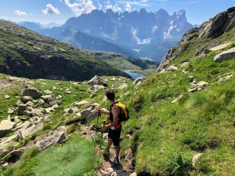
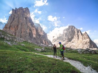
This route starts and arrives in Tonadico, one of the oldest villages in the Primiero Valley. The itinerary is ideal for those wishing to explore the areas, rich with forest and meadows, overlooking the villages of Tonatico and Sirór. The most beautiful point of the trail is definitely when it passes by the location of Piereni, with its beautiful pastures placed in the shadow of the isolated peak of Monte Cimèrlo, in the Canali Valley.
The route begins in the proximity of the church of Tonadico, with a steep stretch along the road that goes from the village towards Strina, climbing E of the cemetery of the Church of San Vittore, that looks the whole village from its isolated position. Right after passing the cemetery, the route continues on a path that starts on the right side of the road and gently climbs the coast towards Val Canali / Villa Welsperg / Piereni, marked as Signpost No. 719.
The trail continues on a mixed background of forest and meadows, with some remarkable views on the several farms and “tabiádi” (tr. huts) of the area. The Signpost No. 719 proceeds along the slopes of the forest, in an increasingly stony way. The last stretch, just before crossing the gravel road that leads to Val Canali, is characterized by the passage on three small wooden bridges. Once on the gravel road, the route proceeds for just over a hundred meters towards the NE, along the road, for than taking the again the path of the Singpost No. 719, which leads directly to the location Pieréni (1,215 m asl), on a last stretch which is very characteristic, with its stone walls.
From the pastures of the wide basin of Piereni, very touristic and always particularly well-kept, the route continues along the asphalted road towards Tàis / Petina which, after passing the meadows of Pieréni, enters a beech forest in a stretch that leads, in just under 2 km, to Tàis (1,212 m asl), a well-known panoramic area and take-off point for paragliders. From Táis the sight opens to the S, overlooking the entire Primiero Valley, with – from E to W – the Cimonega mountain group and the ranges of Vette Feltrine and Lagorai. From Tàis the descent towards the bottom of the valley begins.
Initially, the itinerary follows the paved road towards Tonadico marked as Signpost No. 734, on the wide lawn of Tàis. After a few hundred meters, the road is left behind along a path indicating Poline. Once at the end of the path that runs through a long and narrow meadow to the W of the hut of Maso Tàis, at an altitude of 1,143 m asl, right where the path seems to be almost interrupted, a small track that descends steeply into the forest towards Sirór starts. Following the small track, which will take you to the paved road of Ronchéti (Signpost No. 732), you will be able to reach the center of Sirór shortly.
From the village of Sirór, in order to return to the starting point, it is enough to follow for about a kilometer the road called “campagna alta” (tr. high countryside), which connects Sirór with Tonadico, along the W edges of the field separating the two villages.
Paths
- From the village of Tonadico, climb along the paved road of Tàis, on the E side of the little church of San Vittore [0h 05],
- Once passed the cemetery, take the Signpost No. 719 towards Piereni [1h 10],
- From the location of Piereni (1,215 m asl), follow the paved road towards Tàis [1h 30],
- From the location of Tàis (1,212 m asl), at first follow the Signpost No. 734 towards Tonadico, for then leaving it going along a path with signs towards Poline [1h 40],
- Keep following the path heading downhill, in the beginning appearing like a small track and then along the paved road called Ronchéti (Signpost No. 732), until reaching the village of Sirór [2h 15],
- From Sirór, head back to Tonadico, along the road known as “campagna alta” [2h 30]. ✓
Waypoints


Suggested hikes

- Demanding
Forks at Treviso
Canali Valley,Mis Valley,Pala Group
- Duration: 03:45 hrs
- Length: 6.2 km
- Elev. gain: 513 m

- Demanding
Val de Stua
Lower Primiero,Vette Feltrine Range
- Duration: 05:30 hrs
- Length: 12.1 km
- Elev. gain: 513 m


- Demanding
- Best choice
Leslie Stephen
Canali Valley,Pala Group,Upper Primiero
- Duration: 12:00 hrs
- Length: 29.5 km
- Elev. gain: 513 m