Tour of the Malghe
Malga Venegia - Malga Venegiota - Baita Segantini - Cristo Pensante - Costoncella - Agnelazza - Juribello
gian • 15/09/2019


Details
- Sport
- Hike
- Rating
- Difficulty
- Tourist
- Duration
- 05:30 hrs
- Length
- 13.9 km
- Vertigo
- A little
- Min. elevation
- 1748 m
- Max. elevation
- 2333 m
- Elevation gain
- 650 m
- Elevation loss
- 650 m
- Car park
- View on Gmaps
Terrain
- 25%
- 65%
- 10%
- Forest
- Grass
- Rock
Seasons
- Jan
- Feb
- Mar
- Apr
- May
- Jun
- Jul
- Aug
- Sep
- Oct
- Nov
- Dec
Signposts
Description
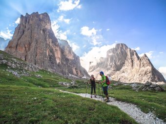
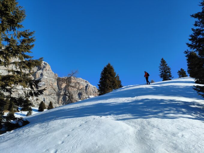
Relative to the commitment it requires and the incomparable beauty of the surrounding environment, this trail falls into the category of the “super classic” of Primiero. Although it is widely popular, especially during the summer season, this route should be done at least once in a lifetime by all lovers of the Dolomites and, more generally, of the Alps. The environment that the itinerary features is that of the vast pastures that extend to the N of Passo Rolle, characterized by the presence at the center of the loop of a rocky relief with a rounded and vaguely crenulated appearance from which the name Castelàz (aka Monte Castellazzo – tr. ugly castle) derives. The summit of Castelàz rises totally isolated from the other mountain blocks surrounding the pastures of the Rolle Pass, with steep porphyritic walls. The proposed route accomplishes the complete loop around Castelàz, in its most classic version (with departure and arrival in Val Venegia), and optional detour that allows you to reach its summit, which – besides being an exceptional panoramic balcony over the northern chain of the Pale di San Martino and Val Travignolo – has several remains of the Great War fortifications, consequently adding historical interest to this fantastic trail. For mountain purists who prefer to avoid overcrowding, we recommend tackling this route during the fall, with its peace, colors and unique lights.
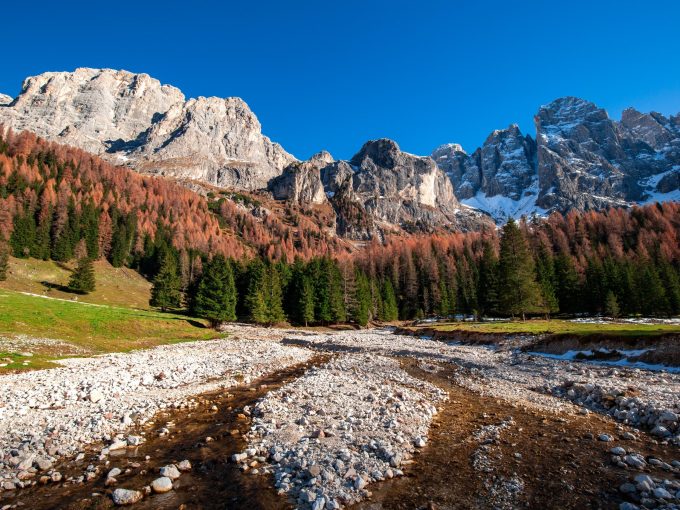
The route starts from the parking lot of the hut of Malga Venégia (1,778 m asl), which can be easily reached from the road that leads from Paneveggio to Valles Pass, turning at the height of the location named Pian dei Casoni. The first section of the route follows the gravel road “Strada Forestale Val Venegia”, which skirts the course of the Travignolo Torrent on its orographic right towards Baita Segantini. The road gradually climbs among wide pastures, offering splendid views of the main peaks of the northern block of the Pala Group: Mulaz, Bureloni, Focobón, Val Grande, Vezzana and Cimon della Pala. After about 45 minutes you arrive at the hut of Malga Venegiòta (1,824 m asl), where the road proceeds uphill through the wood until it reaches the wide basin of Pian della Vezzana (~1,930 m asl), which precedes the last stretch of steeper ascent to Baita Segantini, common to the Signpost No. 710A and the trail “Sentiero Italia” (SI).
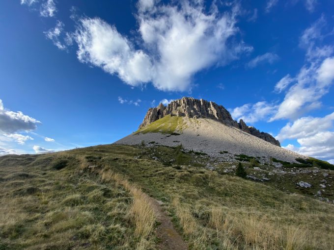
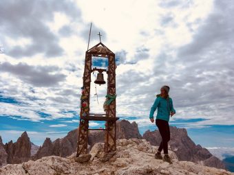
Approximately 2h 30 from the start, after numerous hairpin bends leading toward the High Val Venegia, the itinerary arrives at the hut of Baita Segantini (2,170), beautifully located facing the imposing summit of Cimon della Pala, where the route begins the descent along the gravel road “Strada Forestale Val Venegia” towards Capanna Cervino / Passo Rolle. Shortly before reaching the hut of Capanna Cervino, the hike takes the path towards Castelàz, on the right, that climbs rapidly to the N on the eastern slope of the mountain. In just under 45 minutes you will reach the summit of Castelàz (2,333 m asl), which offers a 360-degree view, with the Pale di San Martino to the NW, the Lagorai chain to the SE, the Vette Feltrine peaks to the S, the Group of Cima Bocche to the NW, Catinaccio and Marmolada.
The route continues descending from Castelàz and heading back to Capanna Cervino (2,082 m asl), for then rejoining the gravel road “Strada Forestale Val Venegia” (or one of the many tracks running parallel to it) to the wide crossroads located just above the Rolle Pass, where it proceeds along the track that runs through the pastures slightly downhill to the N towards Malga Juribello (1,868 m asl). Along the track, the itinerary crosses in succession the higher parts of the pastures of Malga Costoncella and Malga Agnelazza, and then reaches the ones of Juribello. Shortly before arriving at the hut of Malga Juribello, about 300 m upstream of the structure, the route leaves the gravel road, turning right to the NE, following the signs to Malga Venégia / Malga Vengiòta. This last section proceeds along a fairly technical and sometimes slippery path, which leaves the Juribello pastures to descend into the forest along the western slope of Castelàz, arriving directly at the ford on the Travignolo Torrent and then at Malga Venégia.
Paths
- From the hut of Malga Venegia (1,778 m asl), follow the gravel road “Strada Forestale Val Venegia” in the direction of Baita Segantini, passing by Malga Venegiota (1,824 m asl) [2h 30],
- From the hut of Baita Segantini (2,170 m asl), follow the gravel road “Strada Forestale Val Venegia” towards Passo Rolle, until you reach the proximity of the hut of Capanna Cervino [2h 50],
- [VARIANT] Take the path that, starting right above Capanna Cervino, climbs the Castelaz, until getting the summit of Monte Castellazzo (2,333 m asl) [4h 00],
- From Capanna Cervino (2,082 m asl), continue along the gravel road “Strada Forestale Val Venegia” and then turn right along the one leading to Malga Juribello [4h 45],
- About 300 m upstream of the hut of Malga Juribello (1,868 m asl), maintain the contour by taking the path towards the NE in the direction of Malga Venegia / Malga Venegiota, until you reach the starting point, at Malga Venegia [5h 30]. ✓
Waypoints

Best choices


Suggested hikes

- Demanding
Forks at Treviso
Canali Valley,Mis Valley,Pala Group
- Duration: 03:45 hrs
- Length: 6.2 km
- Elev. gain: 650 m

- Demanding
Val de Stua
Lower Primiero,Vette Feltrine Range
- Duration: 05:30 hrs
- Length: 12.1 km
- Elev. gain: 650 m


- Demanding
- Best choice
Leslie Stephen
Canali Valley,Pala Group,Upper Primiero
- Duration: 12:00 hrs
- Length: 29.5 km
- Elev. gain: 650 m